 Munich-Venice
A
cache
by IlPadrino
Hidden:
8/25/2008
Size:
 (Regular)
Difficulty: (Regular)
Difficulty:  Terrain:
  (1 is easiest, 5 is hardest)
Munich - Venice
A Hiking Cache
(Link to original cache listing)
28 Legs
3 Countries
1 Route
!!!
560 Kilometers (350 miles)
20000 Meters (65000 feet) altitude difference
Infinite number of impressions
"Nothing impedes us, nothing holds us back."
(Victor Hugo)
From Marienplatz (center of Munich) to St. Mark's Square (center of Venice)
you hike 28 legs on the traditional route (so-called THE "oneiric trail")
described by Ludwig Grassler (red hiking guide with ISBN 3-7654-3994-0
respectively green hiking guide with ISBN 3-7654-4910-5 since July, 2011;
both available by publisher Bruckmann).
Stupidly the Alps are on your way, which definitely causes some ascents
and descents on your way to the south.
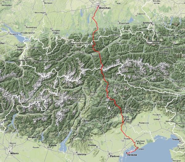
(Image ist linked to track view created with GoogleMaps which can be zoomed)
Special equipment for ice or climbing is NOT required.
Only for the 22th leg it is mandatory to have helmet, clipping
equipment (NEW 2011: at Rifugio San Sebastiano at the
Passo Duran respectively at Rifugio Pian de Fontana it's supposed
to be possible to get the necessary material for rent now
(prior reservation might be necessary !) - I had already propagated
this commercial gap for years
 )
and experience for handling it with you, if you decide
to go the Schiara fixed rope route (via ferrata; terrain: 5).
The alternative (because this leg is not necessary for the cache) is
to use the bus or to go the eastern path, which is "only" very exhausting.
This eastern alternative is still NOT part of the official hiking literature,
but a report (in German language) of Lothar Köster is for example available here:
Link )
and experience for handling it with you, if you decide
to go the Schiara fixed rope route (via ferrata; terrain: 5).
The alternative (because this leg is not necessary for the cache) is
to use the bus or to go the eastern path, which is "only" very exhausting.
This eastern alternative is still NOT part of the official hiking literature,
but a report (in German language) of Lothar Köster is for example available here:
Link
Very helpful for non-German speaking hikers: Link
From my point of view "ONLY" the following is necessary:
- appropriate and already used shoes
- appropriate equipment for hiking more than one day within high mountains
(you can ask me for advice)
- surefootedness
- stable character, to be able to handle such a mental challenge
- at least one time having hiked 2 consecutive days under realistic conditions
(10-15 kg of luggage) 30 kilometers a day within flat country and having survived
(there will be a training cache available in spring 2009)
- stable interpersonal relationships within the hiking team (you'll be together
ABOUT 670 hours almost without interruptions), except you
go on your own, which is also possible of course and always includes the possibility
to join other groups doing the hike
- some experience doing hiking tours within high mountains might be recommended, but
it is not essential, especially because adequate caution is highly recommended by all means
- a reserve of 2-4 days is advised (but it's also possible to do it without
any breaks like we did it), if you want to do it at a stretch (to do it on separated tours
is of course possible, too).
The best strategy: Going, going, going, while weather and healthiness allowing it,
because making a global project plan before starting is wasted time.
- membership within an alpine club (like DAV, OeAV, CAI, ...) is higly recommended
for such a tour, because you'll save money, not talking about all the other advantages.
By the way you'll get fit while that tour without additional training.
The height up to 3000 meters (10000 feet) above sea level is not a problem at all,
too, because you start within the flat country, step by step you get higher and only one
time you'll sleep at 2800 meters within the 3rd week (Boe hut), else you go down again
from the highest point of the day, which is really positive for regeneration and increasing
your ability.
ATTENTION:
Although everybody (even completely untrained persons) with average healthiness
and an age between 14-75 (those people we met on our way) can make that tour on
marked hiking paths, forestry roads, steep tracks, embankments, dirt or paved roads
with staying over night within mountain huts or motels, you shall never forget:
The way is your goal and your own healthiness shall always have the highest priority
while balancing the potential risks, which can occur within high mountains.
Therefore please do NOT have excessive fear, but also do not have fatal readiness to
assume a risk (normally the hosts of the huts are well informed about paths and
weather conditions, you can interview them and shall consider their advice) !
The legs (names of small villages, huts, ... are NOT translated):
| Day |
Start |
via |
Finish |
[km] |
[h] |
up [Hm] |
down [Hm] |
| 1 |
Munich, Marienplatz |
Isar - Kloster Schaeftlarn - Isar |
Wolfratshausen |
32 |
8 |
60 |
0 |
| 2 |
Wolfratshausen |
Isar - Geretsried - Isar |
Bad Toelz |
26 |
7 |
120 |
50 |
| 3 |
Bad Toelz |
Isar - Arzbach - Tiefentalalm |
Tutzinger Huette |
18 |
6.5 |
1000 |
300 |
| 4 |
Tutzinger Huette |
Jachenau - Risssattel |
Vorderriss (better: Oswaldhuette) |
22 (27) |
6.5 (7.5) |
670 |
1220 |
| 5 |
Vorderriss (better: Oswaldhuette) |
Hinterriss - Kleiner Ahornboden |
Karwendelhaus |
24 (19) |
7.5 (6.5) |
1000 |
0 |
| 6 |
Karwendelhaus |
Schlauchkarsattel - Hinterautal |
Hallerangeralm (or: Hallerangerhaus) |
14 |
8 |
1510 |
1510 |
| 7 |
Hallerangeralm (or: Hallerangerhaus) |
Lafatscherjoch - St. Magdalena |
Wattens |
18 |
5.5 |
400 |
1600 |
| 8 |
Wattens |
Lager Walchen |
Lizumer Huette |
16 |
7 |
1490 |
0 |
| 9 |
Lizumer Huette |
Pluderlingsattel - Gschuetzspitzsattel |
Tuxer-Joch-Haus |
11 |
7 |
1150 |
880 |
| 10 |
Tuxer-Joch-Haus |
Spannaglhaus - Friesenbergscharte |
Olpererhuette (Dominikushuette) |
12 |
6 |
830 |
840 (1340) |
| 11 |
Olpererhuette (Dominikushuette) |
Pfitscher-Joch-Haus |
Stein |
14 |
4 (5) |
470 (0) |
700 (850) |
| 12 |
Stein |
Gliederscharte - Engbergalmen |
Pfunders |
16 |
7.5 |
1100 |
1500 |
| 13 |
Pfunders |
Niedervintl - Ronerhuette |
Kreuzwiesenhuette |
23 |
7 |
1.200 |
500 |
| 14 |
Kreuzwiesenhuette |
Wuerzjoch - Peitlerscharte |
Schlueterhuette |
18 |
8 |
1000 |
600 |
| 15 |
Schlueterhuette |
Puezhuette |
Groedner Joch (Puezhuette) |
19 (10) |
7 (3.5) |
1000 (500) |
1170 (670) |
| 16 |
Groedner Joch (Puezhuette) |
Pisciaduhuette |
Boehuette |
7 (16) |
4 (7.5) |
820 (1320) |
90 (590) |
| 17 |
Boehuette |
(Piz Boe -) Pordoijoch |
Fedaiasee |
12 (14) |
6 (7.5) |
240 (540) |
1070 (1370) |
| 18 |
Fedaiasee |
Sottogudaschlucht |
Alleghe (Masare) |
22 |
4.5 |
0 |
1100 |
| 19 |
Alleghe (Masare) |
(Masare -) |
Tissihuette |
12 |
4 |
1350 |
0 |
| 20 |
Tissihuette |
Rif. Vazzoler |
Passo Duran (Carestiatohuette) |
14 (11) |
5.5 (5) |
650 |
1000 (800) |
| 21 |
Passo Duran (Carestiatohuette) |
Forcella Moschesin |
Rif. Pian de Fontana |
18 (21) |
7.5 (8) |
1300 |
1500 (1700) |
| 22 |
Rif. Pian de Fontana |
Schiara: Marmol fixed rope route (or eastern detour) |
Rif. 7° Alpini |
7 |
8 |
670 |
860 |
| 23 |
Rif. 7° Alpini |
Case Bortot |
Belluno |
13 |
4 |
90 |
1200 |
| 24 |
Belluno |
Valmorel |
Revine |
25 |
8 |
750 |
850 |
| 25 |
Revine |
Collalto - Piave |
Priula |
27 |
6 |
350 |
510 |
| 26 |
Priula |
Piave |
San Bartolomeo (Bocca Callalta) |
21 (26) |
5 (6) |
0 |
0 |
| 27 |
San Bartolomeo (Bocca Callalta) |
Piave - Musile |
Jesolo |
36 (31) |
9 (8) |
0 |
0 |
| 28 |
Jesolo |
Punta Sabbioni |
Venice, St. Mark's Square |
24 |
6 |
0 |
0 |
Bonus: Within the area of the 12th leg to Pfunders there exists an interesting
and with good weather very worthwhile chance for a hiking detour to the summit of the highest
mountain around (Hochfeiler, 3510 m), where INCIDENTALLY another cache is available, too
(
Link).
There are different possibilities to do this with or without using an additional day, simply
contact me for advise.
Link to a little appetizer:
(taken from the book about the cache, but without spoilers and private photos - therefore there are some gaps ;-)

The Cache:
Start: Marienplatz, Munich
There's nothing special to do at the starting point, except taking the usual fotos
and starting the tour step by step ... your are starting FINALLY.
|
|
|
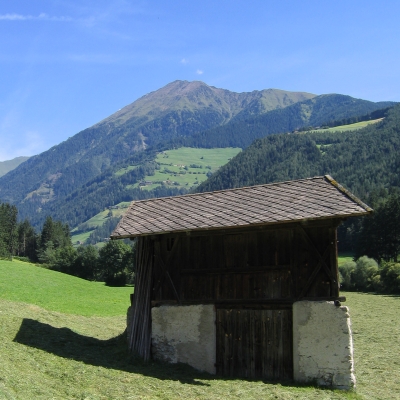
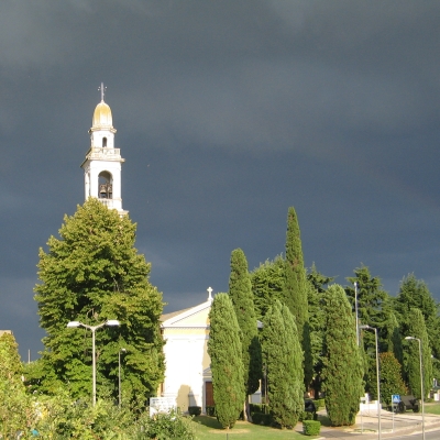
Day 1, Goal: Wolfratshausen
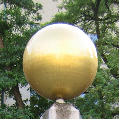
Within the courtyard (no entrance fee necessary) of the German museum ("Deutsches Museum")
there's a model of the sun on a pillar.
What is the diameter of this model, measured in centimeters ?
(A = Number of centimeters) |
Day 2, Goal: Bad Toelz
At N 47° 50.285 E 011° 30.551 is a very lovely place for taking a break.
Stage 15 of the info trail there, explains some historic backgrounds.
When was a well conserved sword made out of bronze found there (number at the begin
of the line with "Bronzeschwert" at the end) ?
(B = Year of the find) |
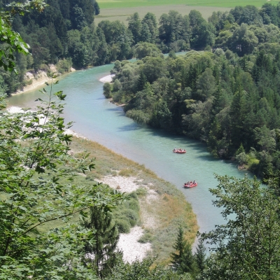
river Isar |
|
Day 3, Goal: Tutzinger Huette
At the outside wall of Tutzinger Huette (near N 47° 39.441 E 011° 27.747) you can see a sign remembering on the release of capricorns.
(C = Sum of alphabetical positions of the first 6 letters of the last word on the sign - 2) |
Day 4, Goal: e.g. Oswaldhuette (or Vorderriss)
After Jachenau at N 47° 34.839 E 011° 26.839 you see a sign above the left window at a wooden hut. Build the sum of the last two digits of the number within the first line.
(D = Sum of the last two digits) |

|
Kleiner Ahornboden |
Day 5, Goal: Karwendelhaus
At N 47° 25.062 E 011° 28.096 you'll find a pilar with a metal panel.
When was the panel installed (number can be found within last line) ?
(E = Year) |
Day 6, Goal: e.g. Hallerangeralm (or Hallerangerhaus)
How many characters has the occupation of the man, who died at
N 47° 21.855 E 011° 26.206 ?
Only the occupation, NOT including the title !
Can be found within the 4th line, the occupation is the first part
of the word including the title "Meister" !
(F = Number of characters of the occupation (without title !)) |

Sundown at Halleranger |
|
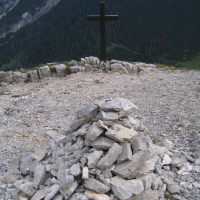
Day 7, Goal: e.g. Wattens (or Hall)
Today you have to be very watchful. While going up from the Halleranger,
you find the point shown on the picture.
Determine the coordinates of the position between the cross and the pile of stones.
(G = Divide the decimal part of the northern minutes by 50 and round it) |
Day 8, Goal: Lizumer Huette
Again you must be very watchful: At which position after the village of Wattens
do you find the shown fingerpost ?
(H = Divide the decimal part of the northern minutes by 50 and round it)
Hint: Do not simply follow the road, but use the REAL and original path (fernwege.de does not contain a saved track !).
|

|

Hoher (Tuxer) Riffler (3.231m), Gefrorene Wand (3.288m), Olperer
(3.476m) |
Day 9, Goal: Tuxer-Joch-Haus
At N 47° 08.219 E 011° 38.100 you find a sign at a pole.
What is the cross sum of the last line of the inscription of the rectangular, white sign ?
(I = Cross sum)
if I is odd: I = I + 5
|
Day 10, Goal: z.B. Olpererhuette (or
Dominikushuette)
At the "Friesenbergscharte" (highest point today, but NOT of the whole tour as
mentioned within ALL guides) you find a sign with an inscription like "??? Zillertaler Alpen".
How many characters do the words have standing BEFORE "Zillertaler Alpen" ?
(K = Number of characters) |

on the "Berliner Hoehenweg" with outlook about Schlegeisspeicher (water reservoir) and
Hochfeiler (mountain and cache) in the background
(
Link) |
|
Day 11, Goal: Stein
At the frontier between Austria and Italy you must have a closer look to the
boundary stone. Note the number which is on the stone.
(L = Number) |
Day 12, Goal: Pfunders
Today there's something to seek on the ground at
N 46° 56 + [N.NNN]
E 11° 40.[EEE]
with
[N.NNN] = A + 2 * C + D + 2 * F + H + (E - B) * L + (L + 1) / 2
[EEE] = C + D + G + I + K
When having found the necessary stage, read and consider the description inside and note the mandatory hints for later.
|

|
|
Day 13, Goal: Kreuzwiesenhuette
At the fingerpost at N 46° 48.004 E 011° 44.626 you look at the
sign showing your direction.
First line: Number of characters before [MALGA]: x
Second line: Number of words before [ALPE]: y
(M = xy) |
Day 14, Goal: Schlueterhuette
Today you find a crucifix at N 46° 44.683 E 011° 49.990.
Above there's an inscription, consisting of how many words ?
(N = Number of words) |

Peitlerkofel |
Shakedown bed ? |
Day 15, Goal: e.g. Puezhuette (or Groedner Joch)
The picture is the OLD Puezhuette (near to the new one). Not shown on the picture
is an inscription consisting of 3 lines of text, right of the extracted section.
Sum up the positions within the alphabet of the last 2 characters of the 3rd line of text.
(O = Sum of the positions) |
Day 16, Goal: Boehuette
Above the main entrance of the Boehuette there's an inscription.
How many characters does the first word have ?
(P = Number of characters) |

Diabolic path: Highway to Hell ? |
Pordoi |
Day 17, Goal: Fedaiasee
At the wall of the Pordoihuette you see a painted picture with some rocks and animals.
How many horns do you count ?
(Q = Number of horns) |
Day 18, Goal: e.g. Alleghe (or Masare)
Today you loose a lot of altitude using ski slopes.
At the position N 46° 26.346 E 011° 54.467 you stand directly below the wires
of a transport system for skiing.
Which kind of system is it ?
- T-bar lift (R = 3)
- Chair lift (R = 6)
- Cablecar (R = 9)
|
View over Alleghesee to the north |
|
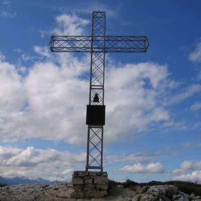
Day 19, Goal: Tissihuette
The shown cross on the summit is only 5 minutes away from the Tissihuette.
You should go up the short path to the cross, because on one hand you have a really exciting
outlook (good weather assumed) and on the other hand you are interested, when the panel
had been assembled to the cross.
(S = Year of the panel) |
Day 20, Goal: e.g. Passo Duran (or
Carestiatohuette)
At the hut Rif. Vazzoler you take a short break. At the area before the main entrance
there are a lot of tiles made out of stone attached to the wall, remembering some persons.
Seek Mario X, Domenico Y and Corrado Z.
Sum up the length of their surnames X, Y, Z
(T = Sum of the lengths of the names) |
|


|
Day 21, Goal: Rif. Pian de Fontana
Above the front door there's a sign, where the same letter can be seen within two lines directly one upon the other.
(U = Alphabetical position of the letter) |
Day 22, Goal: Rif. 7° Alpini
Today you concentrate on the technically most difficult leg.
Have fun, fantastic weather and good luck for the fixed climbing route over the Schiara.
|

Forcella del Marmol |

Piazza in Belluno |
Day 23, : Belluno
After the (hopefully) great experience of the day before and the chilling out walk
out of the Alps there's no mission to do for the cache.
Just relax and enjoy the changing landscape regarding Mediterranean flora and fauna.
|
Day 24, Goal: Revine
You pass the sign marking the limits of the village Tassei.
What is forbidden there ?
- Nothing (V = 2)
- Overtaking (V = 4)
- Hooting (V = 6)
|
|
Day 24 (alternative route), Goal: Col Visentin
Above the door of the chapel at the summit at N 46° 03.369' E 12° 16.948' you'll find a year written in Roman numerals.
(V = Cross sum of the year using Arabian figures) |
 |
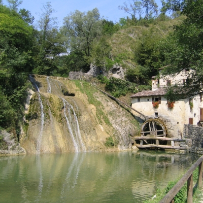
Mulinetto della Croda |
Day 25, Goal: Priula
The time without proper and reliable maps and signs is starting, somethimes even
contradicting themselves.
Have a look at the fingerpost of Munich-Venice (Muenchen-Venedig)
at N 45° 58.195 E 012° 12.857: Which number is THERE inscribed for the current route ?
(W = Number of the route) |
Day 26, Goal: e.g. San Bartolomeo (or Bocca
Callalta)
Within the street Via Argine you find a lost place at N 45° 44.200 E 012° 23.477.
Not in best conditions, but the street number is still readable from the street.
(X = Street number) |
San Bartolomeo |
|
Day 27, Goal: Jesolo
Before reaching the city of Jesolo, you pass a ruin from former times at
N 45° 32.668 E 012° 35.962. Have a closer look at the presentation board and the
small building itself. At the front, right of the entrance you find 2 characters, 1
little man and how many stylized animals (don't count the missing one) ?
(Y = Number of animals) |
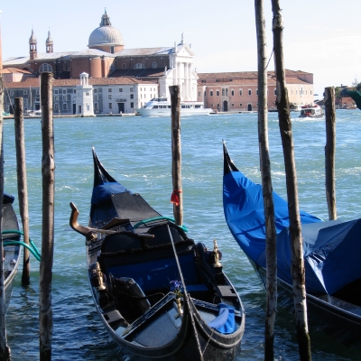
Day 28, Goal: Venice
You arrive at the goal. Almost. The compulsive "photo finish" at the St. Mark's Square
is still missing ... |
|
|
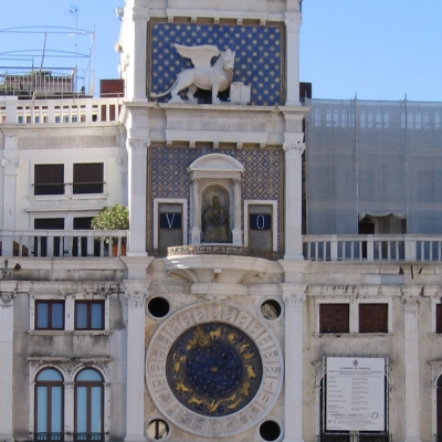
St. Mark's Square, Venice:
... there's still one remaining last question: On the roof of the shown building,
with the clock using Roman figures for hours and Arabian figures for the minutes,
there are how many "persons" hammering the bells ?
(Z = Number of persons) |
The finale:
Go to:
N 45° 26.[NNN] + Offset: 11
E 12° 19.[EEE] + Offset: 28
with
[NNN] = (S - W - M) / 2 + O + Z + X
[EEE] = N * P + 2 * Q * T + R * X + U * V * Y - X + P
You stand opportunely there and you know, what to do now ...
|

|
Now, it's time for YOU simply to ask yourself very seriously,
what The Clash asked themselves already at the begin of the 1980s:
Should I Stay or Should I Go
?
Break a leg and happy hunting
!
Last but not least:
Please do not provide ANY spoilers within logs and comments !
Due to current incidents (2010-09-17): Logs
containing spoilers will be deleted immediately in the future.

Free speech, but no spoilers.
Version of Listing: 2016-11-17
Additional Waypoints
|
|
|
Prefix |
Lookup |
Name |
Coordinate |
|
 |
 |
01 |
MV01 |
MV Stage 01 (Question to Answer) |
N 48° 07.810 E 01° 35.009 |
[Map] |
| Note: |
Stage 01 |
|
|
|
02 |
MV02 |
MV Stage 02 (Question to Answer) |
N 47° 50.285 E 011° 30.551 |
[Map] |
| Note: |
Stage 02 |
|
|
|
03 |
MV03 |
MV Stage 03 (Question to Answer) |
N 47° 39.441 E 011° 27.747 |
[Map] |
| Note: |
Stage 03 |
|
|
|
04 |
MV04 |
MV Stage 04 (Question to Answer) |
N 47° 34.839 E 011° 26.839 |
[Map] |
| Note: |
Stage 04 |
|
|
|
05 |
MV05 |
MV Stage 05 (Question to Answer) |
N 47° 25.062 E 011° 28.096 |
[Map] |
| Note: |
Stage 05 |
|
|
|
06 |
MV06 |
MV Stage 06 (Question to Answer) |
N 47° 21.855 E 011° 26.206 |
[Map] |
| Note: |
Stage 06 |
|
|
|
09 |
MV09 |
MV Stage 09 (Question to Answer) |
N 47° 08.219 E 011° 38.100 |
[Map] |
| Note: |
Stage 09 |
|
|
|
10 |
MV10 |
MV Stage 10 (Question to Answer) |
N 47° 04.444 E 011° 41.551 |
[Map] |
| Note: |
Stage 10 |
|
|
|
11 |
MV11 |
MV Stage 11 (Question to Answer) |
N 46° 59.684 E 011° 39.620 |
[Map] |
| Note: |
Stage 11 |
|
|
|
13 |
MV13 |
MV Stage 13 (Question to Answer) |
N 46° 48.004 E 011° 44.626 |
[Map] |
| Note: |
Stage 13 |
|
|
|
14 |
MV14 |
MV Stage 14 (Question to Answer) |
N 46° 44.683 E 011° 49.990 |
[Map] |
| Note: |
Stage 14 |
|
|
|
15 |
MV15 |
MV Stage 15 (Question to Answer) |
N 46° 35.372 E 011° 49.782 |
[Map] |
| Note: |
Stage 15 |
|
|
|
16 |
MV16 |
MV Stage 16 (Question to Answer) |
N 46° 30.880 E 011° 49.433 |
[Map] |
| Note: |
Stage 16 |
|
|
|
17 |
MV17 |
MV Stage 17 (Question to Answer) |
N 46° 30.108 E 011° 48.743 |
[Map] |
| Note: |
Stage 17 |
|
|
|
18 |
MV18 |
MV Stage 18 (Question to Answer) |
N 46° 26.346 E 011° 54.467 |
[Map] |
| Note: |
Stage 18 |
|
|
|
19 |
MV19 |
MV Stage 19 (Question to Answer) |
N 46° 23.285 E 012° 01.984 |
[Map] |
| Note: |
Stage 19 |
|
|
|
20 |
MV20 |
MV Stage 20 (Question to Answer) |
N 46° 21.244 E 012° 01.876 |
[Map] |
| Note: |
Stage 20 |
|
|
|
21 |
MV21 |
MV Stage 21 (Question to Answer) |
N 46° 15.714 E 012° 10.573 |
[Map] |
| Note: |
Stage 21 |
|
|
|
24 |
MV24 |
MV Stage 24 (Question to Answer) |
N 46° 04.019 E 012° 14.693 |
[Map] |
| Note: |
Stage 24 |
|
|
|
25 |
MV25 |
MV Stage 25 (Question to Answer) |
N 45° 58.195 E 012° 12.857 |
[Map] |
| Note: |
Stage 25 |
|
|
|
26 |
MV26 |
MV Stage 26 (Question to Answer) |
N 45° 44.200 E 012° 23.477 |
[Map] |
| Note: |
Stage 26 |
|
|
|
27 |
MV27 |
MV Stage 27 (Question to Answer) |
N 45° 32.668 E 012° 35.962 |
[Map] |
| Note: |
Stage 27 |
|
|
|
28 |
MV28 |
MV Stage 28 (Question to Answer) |
N 45° 26.026 E 012° 20.395 |
[Map] |
| Note: |
Stage 28 |
|
For online maps...
|
A lot of users watching this cache.
 Attributes Attributes
|

